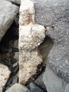


I went on a walk with my camera again. These new photos are only 3 weeks after the first set of photos from my last blog. Frank Quan said that the seawall goes down 30 feet. See in the first two photos that a cave is forming behind the seawall right where it last failed. The horizontal bit of cement you see in the top portion of this photo is the bottom of the road.

The last photo shows the now complete loss of sand from last summer's dredge and beach fill, which was level with the street. Also you can see a hole forming in the seawall. The wall is only as thick as my hand. This hole goes from the tip of my fingers to my knuckles, leaving only 2 inches until it really is a hole. Judging by the previous photos, when that happens, a cave will form behind the wall.
Oceanside does not have a plan in place to address the eroding and dynamic coastline. It is obvious that the rip-rap is no longer doing its job, the initial repair of the failed road is failing, and the seawall is being damaged by the surf. Oceanside's big hope lies in a SANDAG study that is being done that will determine an extensive $50 million sand replenishment project to start in about a year and a half. Until then, they will fill the beach with sand from the dredge the Army Corps of Engineers does every year on the harbor mouth.
I think Oceanside needs some science behind the next beach fill. It seems that just dumping dredged sand on the beach does not help preserve the beach. In fact, without science, how do we know that the problems facing the Strand were not made WORSE by the fill? I also think planned retreat is something that Oceanside needs to start discussing. The homes west of the bluff from Tyson to Wisconsin are on the beach, and soon new measures will need to be enacted to "save" them from the encroaching tide.