After a year of stakeholder outreach and community feedback, San Diego’s Draft Coastal Resilience Master Plan will be presented to city decisionmakers during the next couple months, culminating with the City Council. The plan outlines proposals to protect San Diego’s most popular beaches from sea level rise, and is part of the broader Climate Resilient SD initiative.
Sea level rise threatens San Diego’s beaches, culture, economy, and coastal infrastructure. Just one foot of sea level rise (expected by 2050) can reduce beach width by over 50 feet, potentially devastating narrow beaches like Tourmaline and OB Pier. With 3-6 feet of sea level rise (SLR) and increased coastal storms predicted by 2100, the time to plan is NOW.
Currently, Ocean Beach is most likely to be selected as the pilot project. The plan is to bring the site to a 15% design, which will allow the City to apply for additional state funding. Because the grant funding for this project supports additional design work, the City Council will select two more of the five sites to prioritize beyond OB. City staff has recommended Mission Beach and Sunset Cliffs. While we'd rather not play favorites, our chapter is supportive of staff's recommendation because the project concepts for Tourmaline and La Jolla Shores should be improved before moving forward into design.
Most of the concepts involve engineering vegetated sand dunes along the back beach, and potentially reconfiguring adjacent areas to create buffer zones where beaches can migrate inland as sea levels rise. Surfrider supports these concepts, but we’re recommending more ambitious proposals for several of the sites (mainly Tourmaline & La Jolla, but OB too). You can see our comments on each concept in the tabs below. We recommend first reviewing the project concepts in the Draft Coastal Resilience Master Plan (pages 21-48). Each is explained in detail, with various illustrations and schematics to help with visualization.
The Master Plan contains two concepts for La Jolla Shores (Concept B-1 and B-2). B-1 maintains the existing layout of the parks and parking lot, proposing additional flood protection in the form of a raised “earthen dike” fronting the park, and a raised “seatwall” fronting the parking lot. Here is a cross-section from the plan:

B-2 would reconfigure the the park and parking lot, lengthening the park across the entirety of space behind the boardwalk and putting the parking lot behind it. Same square footage of park and parking lot, but more resilient layout. This redesign is the clear winner for increasing coastal resilience, therefore we favor it. Check it out:

Lengthening the grass area across the entire back beach would create a uniform buffer space to absorb coastal flooding (the plan calls it a “floodable waterfront park”). It would also allow for future migration of the beach over the grass, once sea levels rise enough to warrant it. Meanwhile, the parking lot could be redesigned with better efficiency in mind.
Neither concept suggests pulling back the existing seawall and boardwalk, however, which is a miss for coastal resilience. We understand that the boardwalk is a popular amenity. But waves breach the seawall during annual King Tides and flood the boardwalk (photo below from 2024), rendering both the beach and the boardwalk unusable. This will occur regularly by end of century.
The wall is already in fairly bad shape, and will begin to fail. Without a clear understanding of how seawalls worsen erosion and lead to permanent beach loss, community pressure will mount to replace and/or enlarge the seawall. It would be an improvement to move the boardwalk behind the reconfigured park.

Surfrider maintains that Concept B-2: Reconfigured Park offers more long-term viability to one of the City’s most popular beaches, especially if the seawall and boardwalk are pulled back as well. Whenever feasible, relocation of hard infrastructure away from an encroaching ocean is indisputably the simplest and most effective way to preserve our beaches and increase SLR resilience at the same time. It should be prioritized.
The main idea is to cover the existing rock revetment that protects the parking lot into a hybrid sand dune, by filling it first with cobble and sand, then vegetating it with native dune foliage. This would be similar to the Cardiff Living Shorelines project, which covered a rock revetment protecting Highway 101 with hybrid vegetated dunes. While it would be a visible improvement, we believe this proposal adds insufficient sea level rise resilience to an eroding beach that's already pinched at high tide. Cross-section:

The biggest impediment to SLR resilience at Tourmaline is the parking lot’s current location, which already necessitates shoreline armoring, i.e. the existing revetment. The revetment occupies valuable beach space, where it exacerbates beach erosion by interrupting the natural interaction between waves and the landscape. Covering it with a dune fails to address the underlying problem, ignoring a much greater opportunity to preserve Tourmaline in the face of rising seas and worsening erosion.
We’d like to see a concept that that pulls the parking lot in, which would immediately widen the beach and provide more space for the beach to migrate landward. If the parking lot’s grassy areas were replaced with additional car spaces, enough space would be freed up to move the seaward border of the parking lot landward. The bathroom would ideally be moved as well, but could also be left in place with a much smaller armoring footprint.


It feels strange to recommend removal of green space for car parking, but it’s warranted under this circumstance because it would facilitate the preservation of threatened coastal resources without negatively impacting public access (i.e. minimal to no net loss in parking). Let's be honest - these green spaces are underutilized. By and large, people come to Tourmaline to access the beach and ocean, not to enjoy ill-sited grass areas with a view of parked cars. Creation of more SLR-resilient beach space should take priority over preservation of these non-coastal dependent resources.
Needless to say, these ideas would need to be explored in detail to determine feasibility. However, the starting point to improve Tourmaline’s resilience should include relocation of the parking lot and revetment, or relocation of the parking lot coupled with replacement of the revetment with engineered dunes. The beach cannot thrive under existing conditions due to the parking lot’s location, a situation that will only become worse as sea levels rise.
Two options were included for Mission Beach (D-1 and D-2). Both include installation of a permanent, vegetated dune across the back beach to retain sand and protect the boardwalk from flooding during storm surge events. These vegetated dunes would replace the City’s Winter Berm program, which involves building sand dunes across the beach every Winter to keep coastal flooding at bay. Check it out:

Beyond the dunes, we prefer adoption of Project Concept D-2: Perched Beach because it incorporates the creation of additional sandy beach space. Currently there is ample beach and park space at Mission Beach, but beach space will indisputably shrink as sea levels rise. Beach recreation space must be given priority over grass parkland on the coast; a park can be anywhere, a beach cannot. In the rendering below, the blue #1 is where the proposed add'l perched beach would go:

Echoing our comments for the previous project designs, the City should take every opportunity to move the beach landward where it’s possible to do so. Landward migration of the beach, wherever feasible, is the most effective, durable, and cost-effective nature-based solution to preserve this critical recreational space.
Similar to Mission Beach, the proposals at OB include replacement of the Winter Berm program with permanent, vegetated dunes across the back beach. We agree that this would be an improvement, providing similar benefits to the Winter berms but with added habitat and aesthetic value.
For Dog Beach, we’re most supportive of the Project Concept D-2, Resilient Relocation, because it includes relocation of a bathroom which will eventually become threatened by SLR. And although it does not speak to coastal resilience, the proposed multi-use path from Dog Beach to the Pier would increase connectivity across the beach community.

For this area, we also encourage a more detailed look at ways to reorient underutilized space in the Dog Beach parking lot to increase overall beach resilience. Brighton Park, which runs the entire length from Brighton to Voltaire, is underutilized because it fronts the parking lot rather than the beach itself.
The idea would be to move the park seaward and replace it with the lost parking spaces, i.e. swapping the grass with the parking lot. Doing so would create an attractive beachfront park that is unobstructed by parked cars. A floodable park would also add an additional layer of resilience, by protecting the infrastructure behind it from coastal storm surge. This would likely add another 1-2 feet of sea level rise resilience to the area.


Swap the park with the parking lot and everybody wins!
The concept for the OB Beachfront - Pier area runs from roughly Cape May to the pier, and involves the installation of dunes along the back beach, similar to Dog Beach and Mission Beach. We support this concept as a short to medium-term strategy.
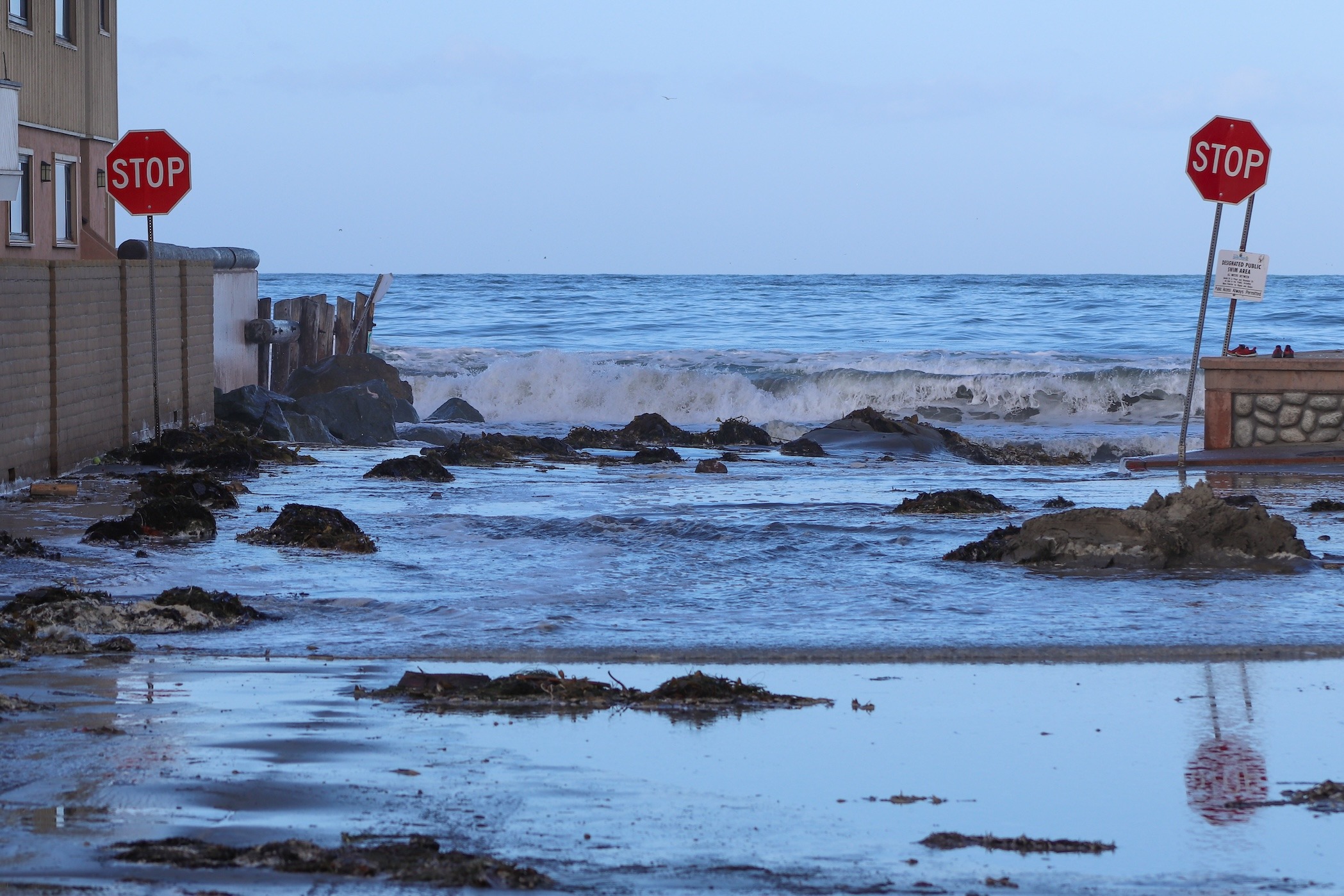
The beach directly in front of OB Pier is fairly eroded, with a narrower beach that is swallowed completely during an extreme high tide (see photo below, Jan 2023). Engineered dunes are unlikely to extend this far south as they may not be durable in front of such a narrow beach/existing seawall.

Options to preserve beach recreation space here are limited, unless the City commits to realigning the entire boardwalk in this area and possibly moving the pier parking lot and/or Veteran's Plaza back. No such concepts were explored in the Draft Master Plan, but they could be considered as part of the ongoing OB Pier replacement planning.
Surfrider generally supports all of the proposals outlined in Project Concept F-1: Resilient Cliff Design Options. A one-way street from Cordova to Ladera will calm traffic and create more space to realign the bluffside parking lots away from the cliffs, as well as create a continuous dedicated pedestrian and/or bike path. These would all be welcome additions to Sunset Cliffs.
Reorienting the parking lots away from the cliffs is especially notable for increased coastal resilience, as it will provide space to allow more natural cliff erosion before infrastructure (i.e. parking lots, the street, etc.) becomes threatened. We also agree that blufftop space should be prioritized for recreational use rather than parking lots, especially when coupled with angled parking along the street to minimize loss of spaces.
Stormwater improvements to minimize runoff over the eroding cliffs would also be welcome, and much-needed, throughout the entire Sunset Cliffs area.

 Mitch served in various volunteer leadership positions with the San Diego Chapter before being hired on as Chapter Manager in 2018. In 2022, he transitioned to the chapter’s policy role. In 2025, he's broadened his scope as California's Senior Policy Coordinator.