
Living with sea level rise presents challenges to maintaining public infrastructure and private property in San Diego.
by Montana Denton
Denton is a graduating USC Environmental Studies student who originally published this piece as a climate journalism project. We've republished here with her permission. While the article provides an excellent overview of the issues our chapter works on, it is not meant to speak for The Surfrider Foundation.
When you think of Del Mar, California, the railway is likely not the first thing to come to mind. An affluent locale just north of San Diego, Del Mar is a sleepy coastal town known for its surf breaks and celebrity residents, coming to life every summer with the San Diego County Fair and annual horse racing season. Unless you’re a commuter trying to beat the traffic on the I-5, odds are the railway is just a minor inconvenience, a brief lapse in the tranquil sounds of crashing waves when an Amtrak Pacific Surfliner train thunders past the shore.
Long before the days of multimillion-dollar oceanfront properties and beachside getaways, the California Southern Railroad laid tracks north from San Diego Bay with the intent of connecting with the Atlantic and Pacific Railroads to create a transcontinental line. It passed through Del Mar and continued along the coast to Oceanside, forming the Los Angeles-San Diego short line railroad. In 1909, the Santa Fe Railway company obtained the right to reroute the tracks, and a new line was laid along the coastal blufftop of Del Mar. As soon as the first train passed over the new line, challenges to the blufftop route were evident. Despite decades of engineers’ best efforts, since 1910, three trains have fallen to the beach — most recently in 1941 when heavy rains softened the roadbed on the embankment and a northbound freight train slid down toward the beach, resulting in three deaths. Although railway catastrophes have since been avoided, constant erosion and dramatic bluff collapses in the past century have reemphasized the gamble of building on the cliffs, and it’s almost inevitable that the railroad will be moved again.
Any good climate story these days possesses an element of attribution science — a field of study that seeks to measure how ongoing climate change is directly impacting extreme weather events. But declaring something a product of climate change is never quite so simple. In the City of Del Mar, there are no winners and losers. Just a community of people trying their best to deal with a hand that’s already been dealt. Dr. Adam Young, a coastal processes scientist at San Diego’s globally-renowned research establishment, the Scripps Institution of Oceanography, is leading the charge: “I get asked all the time when a landslide happens, is it climate change? The answer is, we don’t know really, the cliffs have been eroding for thousands of years,” he said. “Can you attribute that specific event to climate change? It’s not that simple.”
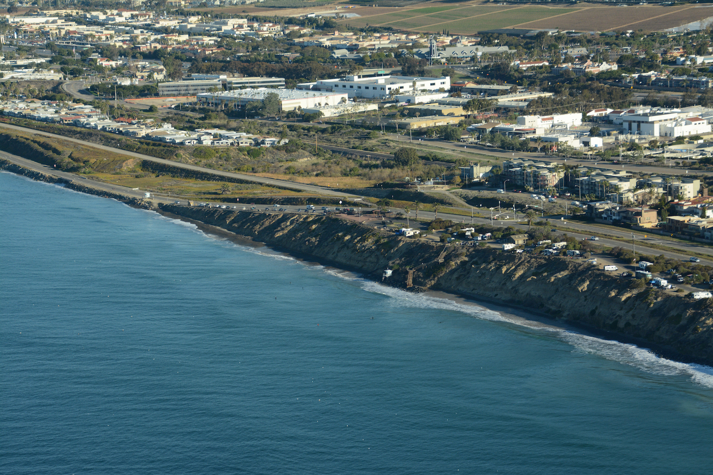
Every day, people traipse up and down the leveled sandstone at the top of the cliffs. Joggers and visored walkers stride briskly along the bluffs. Countless beachgoers, phones in hand, casually cross over the rusted railroad tracks for the perfect shot, mere inches away from the cliff’s edge. The air changes before the train approaches, an almost inaudible tinny sound fills the air as the Amtrak Pacific Surfliner rushes by, as it does several times each day. Surfers, hefting colorful boards, pick their way across the rails to the surf breaks of South Del Mar. On the beach several stories below, signs stick out of cliff-clinging vegetation and piles of debris from previous bluff failures, cautioning beachgoers of the danger of falling rocks — a euphemistically-phrased warning to remind passersby to mind their distance from the towering bluffs overhead. Del Mar is, so to speak, a city clinging to the calm before the storm.

Despite the aforementioned structural challenges, the 1.7 mile stretch of railway on the sandstone bluffs of Del Mar is part of the second-busiest rail corridor in the nation. The Los Angeles-San Diego-San Luis Obispo (LOSSAN) Corridor runs 351 miles in total, with tracks being used by the COASTER and Metrolink commuter trains, Amtrak passenger trains, and the Burlington Northern Freight Corporation. Undeterred by a dip in utility during the height of the pandemic, the rail corridor accounts for a combined 7.6 million passengers per year and transports nearly $1 billion dollars in goods and services, both of which are projected to increase within the decade. The sixty-two mile stretch of track — owned by San Diego’s North County Transit District — is called the Surf Line due to its close proximity to the Pacific Ocean, in some places within less than 100 feet of the shoreline. The railway boasts expansive ocean views and a traffic-free method of travel between LA and San Diego, but the potential losses far outweigh the temporary gains. Despite many logistical disagreements, Del Mar City Council member David Druker said, “The biggest priority is to get the train off the bluffs, and I think most of the people in Del Mar, most of the people in the county, would agree.”
Like many coastal cities in California, San Diego’s crown jewel is its beaches. From the dramatic sandstone vistas and sweeping oceanfront views of Torrey Pines State Natural Reserve to the epic swells at Black’s Beach, San Diego offers visitors and locals alike an idyllic, laid-back lifestyle. Much of California’s most rapid growth, particularly in coastal counties, occurred between the years of 1945 to 1978. This post-World War II era coincided with a period of peaceful coastal climate due to a cool Pacific Decadal Oscillation cycle. During these years, newly-built coastal communities generally avoided damaging storms and heavy rainfall, resulting in less erosion and flooding. While Southern California has experienced stormier El Niño seasons since, effects have only been amplified in recent decades by rising sea levels.
Until about 150 years ago, global sea levels had been relatively stable, but due to rampant fossil fuel use and a subsequent increase in greenhouse gas emissions, notable sea level rise has been documented around the world, including along the California coast. When asked about sea level rise, Dr. Gary Griggs, a coastal geologist at UC Santa Cruz, said “It’s a slow process, and if we melted all the ice on the planet today, we could raise sea level about 216 feet. So, there goes all of Los Angeles, San Francisco, and San Diego. Nobody thinks that’s going to happen this year or next year or this century or next century. But we don’t need 216 feet. Five feet is going to make a huge difference.” Although the physical manifestation of the rising seas is still somewhat variable, what we do now will impact what the future may bring, he explained. The more carbon dioxide we emit, the faster our glaciers melt, accelerating the rate of the rising seas. While mere inches of rise will likely bring great ramifications to coastal communities, the seas may swell by nearly 9 feet at the end of the century in some places, with the tides bringing in greater risks of flooding, wave-driven erosion, and saltwater intrusion of groundwater tables.
Caught in a landslide
Today, 67% of the state’s population resides in coastal counties, with many living as close to the water as they can realistically afford. Choosing to build next to the sea has some obvious perks — incomparable views, constant beach access, and enviable property value, to name a few. But there’s also inherent danger in having the ocean as your next-door neighbor — crumbling cliffs, periodic flooding, and shrinking beaches all come with the territory of dwelling along San Diego’s seventy-mile shoreline. Towering several stories above the beachside below, the famous cliffs that frame much of the city’s coast are a breathtaking testament to the passage of time and the power of the ocean. These uplifted marine terraces are walls of rock that are several thousands of years old, and generally composed of sedimentary rocks like sandstone and siltstone. According to Dr. Young, the cliffs experience two major erosional processes — the repeated wave action at the base, and the impact of rainfall and seeping groundwater weakening the top layers of the cliffs. Both processes can gradually eat away at the stability of the cliff, although bluff erosion rates depend on a culmination of factors. Young and his team have spent the past several years conducting surveys of coastal cliffs throughout the county using LiDAR, a system that scans the cliff faces with a high-resolution laser.
Equipped with truck and drone-mounted sensors, Dr. Young has a survey crew mapping the stretch of bluffs in the South Del Mar and North Torrey Pines areas at least once a week in order to measure how the faces of the cliffs are changing over time. Finding erosional patterns is one of the things that he’s been studying, and he’s found that one small event can trigger a much larger landslide. “Sometimes when a small event happens, it can redistribute the stress to the surrounding area, and can cause another event to happen in the adjacent area. It’s similar to earthquake processes, that can include a series of foreshocks, the main event, and then aftershocks,” he explained.
There’s still work to be done, but Young has determined that rainfall, wave height, and erosion rates are all higher during the winter, when beaches are experiencing maximum wave action from the strong swells of winter storms. Young’s ultimate goal is to quantify cliff erosion, creating a complex algorithm that could be used to model future coastal evolution and inform regional decision-making and policy. Until then, he says, beachgoers should take average erosion rates in the area — around 6 inches per year — with a grain of salt. Over time, wave action and storm surges at the base of the cliff cause instability that will eventually lead to a cliff-top failure, which can often cause significant chunks — up to twenty or thirty feet — of the cliffs to crumble off overnight.

Although the railway has remained relatively untouched, the coastal North County region of San Diego has experienced several major cliff instability events in recent years — including a 2019 collapse at Grandview beach in Encinitas that caused three fatalities — that have called attention to the precariousness of coastal infrastructure and homes. Since then, the City of Del Mar has experienced several episodic bluff collapses that have prompted short-term interruptions of railway service and emergency repairs to patch up the areas. Each time the bluffs shift, potentially millions are spent on what are essentially short-term solutions. According to Dr. Griggs, each coastal incident is followed by debates over whether rebuilding is the right choice.
The relocation of critical infrastructure
There’s no quick fix to remove century-old infrastructure from a crumbling mass of sandstone, so in the meantime, responsibility has fallen to San Diego’s regional planning agency, the San Diego Association of Governments (SANDAG) and the North County Transit District to come up with a long-term strategy. While SANDAG has found no evidence that the railway specifically contributes to greater erosion rates, since 2003, the organization has been carrying out a series of bluff stabilization projects in order to prolong the lifespan of the tracks. Considering factors like soil type, water seepage, steepness and retreat rate, the agency has conducted numerous geotechnical studies to determine high-risk areas and subsequently allocate funding for construction plans. The fourth project was completed in 2021, and the upcoming Project 5 will focus on longer-term stabilization strategies, installing additional support columns and focusing on improving runoff drainage channels. To date, the agency has spent around $18 million on stabilization efforts and plans to spend around $64 million more in protection through 2050.
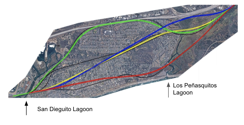
In the meantime, there have been several suggestions for where the railway should be relocated instead, most of which include moving the train inland and underground. Current estimates for the project are around $3 billion dollars, and over a decade until completion, depending on which alignment is selected and when funding becomes available. The proposed route, which is intended to be at roughly the same level as the existing cliffs, will require tunneling horizontally deep beneath the streets of Del Mar. Aside from the obvious safety benefits of being moved off of the bluffs, a new line offers increased railway capacity, speed, and commute efficiency. In the meantime, SANDAG, whose Project 5 plans were greenlit by state coastal authorities in June, will continue its Sisyphean task of holding the crumbling cliffs together.
Bolstering the bluffs
Beaches naturally fluctuate over the course of the seasons and despite SANDAG’s best efforts, it’s impossible to manipulate them into permanently staying still for the purpose of our own existing infrastructure and dwellings. They can retreat seasonally, shrinking as a result of powerful winter storms and expanding with the lapping waves of summer. As infrastructure and higher tides have seeped across our coastlines in the past century, so have the strategies for mitigating the unpredictability of the oceans. According to Dr. Griggs,”When you get right down to it, there’s only about four solutions. One is denial, or do nothing. That’s the cheapest, and it doesn’t cost anything until the storm or king tide and waves hit. That’s okay, it’s just not going to be a long term solution.”
“Then,” Griggs continued, “there’s armor. And that’s what we’ve done for the last century. Seawalls, revetments, some kind of barrier. Southern California is now 38% armored, but there are impacts of armor. There’s aesthetic impacts, they take up beach areas, they cut off the sand supply from the cliffs, they prevent access. And depending on the structure, they may have only a short lifetime.” In South Del Mar, there’s no shortage of seawalls plastered across swathes of bluff deemed questionable. Some are remnants of the past, indiscreet cement walls painted beige as if to match the bluffs around it. Others are newer, facades of dark wood and sturdy metal pillars, reinforced with piles of boulders. Walk further north to the flatter portion of the beach and you’ll see a conglomeration of low cement seawalls literally built into the sand, fortifying the beachfront houses on the aptly-named Ocean Front. Just south of Del Mar, Torrey Pines State Beach features a similar hard-armoring strategy. Beachgoers who are lucky enough to find a space in the packed parking lot overlooking the ocean must scramble down slanted piles of boulders stacked onto the sand, known as riprap. Revetments, which can take many forms but are often utilized with riprap, are commonly-used sloping structures that intercept and slow down high-energy waves to minimize further beach erosion.
Hard armoring strategies exist to protect property, not the beaches below. They’re relatively effective at smothering the natural rates of erosion from bluffs, which is ideal for homeowners trying to protect their property, but only worsen the disproportionately low resupply of sand to the beaches via natural erosion processes. In an arid Mediterranean climate like Southern California, water is a precious resource, but the lengths we go to collect it have long-term impacts on sediment replenishment channels. Engineered water catchment strategies like concreted river channels, dams, and flood control mechanisms stop the natural flow of sediment to the coast, creating sand-starved beaches. As sediment pathways are sealed and sea levels continue to swell, continued seawall construction opens up the possibility of beaches being swallowed by the ocean completely.

Speaking of sand, the third strategy, according to Griggs, is nourishment. The classic soft solution, policy makers tend to favor sand replenishment projects, which involve depositing sand on a narrow, eroded beach to widen it and mitigate the impacts of high-energy waves that would otherwise repeatedly crash against bluffs. Sand can be dredged from offshore, from buildup in jetty entrances, or as a byproduct from construction projects. In recent years, SANDAG has conducted two regional nourishment projects, in 2001 and 2012. After extensive monitoring, researchers concluded that all of the sites that fronted high coastal bluffs experienced nearly a complete loss of the added sand within the first six months. Between the two San Diego projects, the cost landed at around $46 million dollars, much of which is undertaken by local taxpayers. If the shelf lives of past projects are any indication, nourishment is not the most cost-effective solution. Additionally, if the grains of sand are finer than those naturally found at the beach, the newly nourished beach may disappear faster than the beach was originally eroding.
There’s variation in the natural equilibrium of any beach, but if there’s no retention structure, Dr. Griggs argued, then there’s no reason that added sand will stay and widen the beach for any period of time. Much of Griggs’s work on the shifting nature of beaches focuses on the phenomenon of littoral drift, which is the transport of sand parallel to the shore due to waves and currents. Sand is constantly moving, and thanks to the motion of the ocean, is transported down the coast. However, just like river damming, this process of natural replenishment can be impacted by structures like harbor breakwaters and jetties. Conversely, we can leverage littoral drift to our advantage, particularly by building a series of groins that interact with the natural direction of littoral drift. Called the groin effect, it has the potential to retain sand in areas that may be experiencing significant erosion loss. “In general, they trap sand and when that groin area gets filled, the sand will move around and move on down the coast,” Griggs explained. “At the last groin it's going to erode down coast because there's no barrier to trap the sand there.” A buildup of sand in one area — albeit creating a protective buffer for delicate coastal bluffs and infrastructure — may create significant consequences for other beaches further south. Oceanside, the northernmost city in San Diego County, has been experiencing significant beach erosion, in part due to the Oceanside Harbor, which disrupts the north-to-south flow of sand. Rather than focusing solely on sand nourishment projects, the city has proposed the construction of a series of four groins, a pilot project that would replenish their shores at the expense of beaches further south, namely, their neighbors in Carlsbad. A set of groins in Oceanside would get the job done locally, but it would also create the need to build an entire field of groins to make up for interruptions to littoral drift all the way down the coast.
The final coastal preservation strategy mentioned by Dr. Griggs has been constantly disguised under a series of euphemisms. “The words came up a number of years ago called ‘managed retreat’,” Griggs said. “There’s different words that have been used: managed relocation, realignment, community-led relocation, stepping back gracefully. And that’s a global issue.” A catalyst for community discord, political debates, failed legislation, and unsuccessful political reelections, managed retreat is the ultimate last-ditch resort. At some point, sea levels will rise or coastal bluffs will erode to a point where a region becomes uninhabitable. When that day comes, infrastructure and houses will either have to be moved back or abandoned entirely. Human civilization has come up with numerous ways to fight the natural processes of the ocean and coastline, but it doesn’t matter what structure we build — we’re conducting costly repairs on a slowly-sinking ship. “We’re left in a spot where you can add sand to the beach, engineer the coast to try to stop erosion, or back off the coast and let it go. And those are all things that people don’t always agree on,” Dr. Young explained.
The idea of managed retreat has caused understandable controversy between local governments creating sea level rise plans and coastal homeowners who have sunk their life savings into the perfect beachfront view. However, Griggs added, “That’s sort of, ultimately, that’s what is going to have to happen. Anything else is short term. And that’s going to be a function of the future rate of sea level rise, which is accelerating.” Managed retreat is still a sore subject for many, but recent decades have begun to prove the consequences of leaving coastal development unattended and as a result, California is home to some of the most comprehensive coastal policy in the nation.
The Supreme Court of coastal concerns
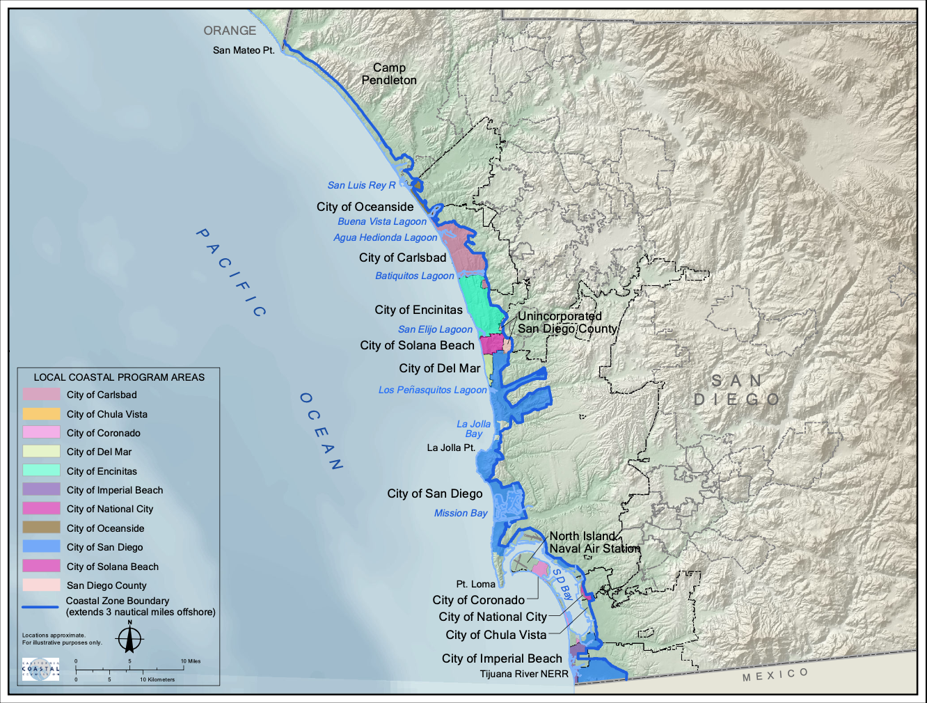
Managing over a thousand miles of coastline is no easy task. During the state’s decades of coastal population growth, rising property values, and intensifying coastal development, Californians passed the California Coastal Act, which prioritized public access to the coast, conservation of natural resources, and established the California Coastal Commission to offer statewide guidance and jurisdiction for coastal development. In order to delegate some coastal planning authority to local governments, the Commission mandated that all coastal counties and cities in the state must create a Local Coastal Program (LCP). Envisioned as city-specific versions of the Coastal Act, LCPs were intended to be planning tools for local governments to determine future development and resource protection in their respective zones.
Effie Turnbull Sanders, who was appointed the Commission’s first Environmental Justice Commissioner in 2016, emphasized the issues when it comes to the establishment of certified LCPs. “The cities and local jurisdictions are required to adopt LCPs but there aren’t any penalties if they don’t. We don’t have any enforcement authority over that. So we’re kind of stuck between a rock and a hard place because we have to make sure the Coastal Act is enforced,” she explained. Turnbull Sanders reiterated that the road to certifying an LCP can be tedious, and incredibly expensive. The Coastal Commission does its best to provide cities with the support that they need to create and update their LCPs for approval, but despite this, as of 2020, only 75% of the LCP segments in California have been effectively certified.
If a coastal city doesn’t have an authorized LCP in place, the Coastal Commission is responsible for reviewing permits regarding coastal infrastructure. Turnbull Sanders admitted that it can be tough to reject Coastal Development Permits for protective seawalls, given that in some cases, a coastal home may be a homeowners’ primary asset, “But part of that the view that we have to take is one that is a statewide view and anytime you have a seawall, you are creating challenges in other areas where behind the seawall, it starts to erode. And so that erosion is eliminating public beach for other folks, which can be an environmental justice and public access issue. Seawalls can also degrade the integrity of other structures, and then it doesn’t allow that natural kind of ebb and flow of the water line to allow for better coastal management.”
In the past, many houses that were built prior to the Coastal Act were essentially grandfathered in, allowed to reinforce existing seawalls with relatively minimal pushback from the Commission. These days, Turnbull Sanders said, the Commission is trying to reiterate to homeowners and infrastructure developers that building a seawall isn’t guaranteed. “What we’ll do is require a permit condition that says, as a standard condition, you’re not entitled to a seawall to protect your property if you build it,” she said. “If a time comes when water starts to come too close to your home and create a dangerous situation — it’s kind of like a buyer-beware situation where you are assuming the risk.” Homeowners and development agencies like SANDAG who get their armoring structures approved are typically required to pay a mitigation fee to offset the damage that their protective barrier might cause — yet another attempt by the Commission to change the attitude around seawalls and deter them from being built.
As frustrating as it may be, the Coastal Commission is reliant upon the cooperation of local coastal communities to take the necessary steps to be legally compliant with their code. Within the San Diego region, most LCPs were last approved in the mid-1980s. In fact, Del Mar has the most updated LCP, which was approved in 2001. With advances in scientific knowledge and improved sea level rise models, updating LCPs is especially important, Turnbull Sanders said. “Sometimes it’s actually not the greatest to have an out-of-date Local Coastal Program like some of the ones from the 80s and 90s that don’t have sea level rise guidance, for example. Folks weren’t thinking about that as much back then, and science has evolved. So sometimes, when you have an out-of-date Local Coastal Program, it can be worse than not having one at all.”
The rulebook for retreat
To its credit, the City of Del Mar is well aware of the potential implications of sea level rise on coastal development. It created and adopted a sea level rise adaptation plan in 2018 that is currently in effect without Coastal Commission certification, although this could create complications in future development projects. When this sea level rise adaptation plan was submitted to the Coastal Commission as an amendment to Del Mar’s original 2001 LCP, the Commission suggested several modifications, including a section on managed retreat for private property. According to San Diego Surfrider’s Policy Manager Mitch Silverstein, local homeowners “thought that if that word was going to be in there, then all of their property values [were] going to plummet. So they fought tooth and nail to get it removed from the program,” and ultimately the plan was removed from Coastal Commission consideration.
City Council member David Druker added “When we created the sea level rise adaptation plan, we said that we did consider managed retreat, and don’t believe that currently identifying that as a strategy makes any sense at this point.” Druker instead recommended that more observation is needed to determine how to best protect the city’s assets. The City of Del Mar is preparing for sea level rise, but failing to cooperate with the Coastal Commission may lead to further complications down the road, compromising existing coastal housing initiatives, potentially limiting eligibility for state climate adaptation grants, and arguably making it even more difficult to obtain the necessary funding for railway relocation.
Although the idea of managed retreat has taken many forms over the years, the general idea remains the same. But whatever disguise policy makers choose to put in front of it to soften the blow, the issue remains — homeowners are understandably staunchly against the idea of abandoning their pricey coastal properties. The first step? Normalizing the managed retreat of public infrastructure, which has been an ongoing process for decades. From the Del Mar railway to constant construction on perilous portions of the Pacific Coast Highway, public property relocation is an optimal chance to destigmatize the idea of managed retreat. While it doesn’t generally evoke the same incensed reaction that reclaiming private property might, there are existing local opportunities to get more public buy-in to the inevitability of retreating. North of Del Mar, a section of Carlsbad Boulevard has suffered severe flooding during king tides and storms. But thanks to a grant from the California Coastal Conservancy, a project plan has been created to realign the street inland, creating a wider buffer zone for the next storm surge.
The same concept goes for the coastal portion of the railway — moving inland is going to be time-consuming and costly, but stakeholders have few options but to get on board. The sentiment towards retreat isn’t going to change overnight, but as sea levels continue to rise and bluffs naturally erode away, the array of alternatives will also get slimmer. When asked about the turning tide, Commissioner Turnbull Sanders said, “I think we’re now evolving as a society where we have to say, okay, it’s not just about your individual property but it’s about the entire coast. It’s about the collective commons where we all have a responsibility to protect and maintain the environment for future generations and current folks as well.”
Losing a home that has been in the family for generations or relocating historical public infrastructure is understandably painful beyond the initial financial blows. However, basic functionality and economic viability are at stake. Much of the burden of short-term interventions is pushed off onto local taxpayers, and at some point, mitigation measures — be it public or private property — will simply become uneconomical. According to Dr. Griggs, we’re better off reaping the benefits of acting now, rather than relying on a stroke of luck to push the inevitable off onto the next generation. He asks,“What time frame are we thinking about? All of our elected officials, whether it’s councilmen or mayors or Congressmen or state senators, serve 2-6 years. So that’s their time frame. If they can get some sand on the beach here in 2 years, they’ll be reelected.” But homeowners are not constricted to the same timelines. Del Mar residents succeeded in postponing the thought of a managed retreat for now, but the imminent drop in home value and potential spike in insurance rates as the sea looms closer are hard to ignore. “You know, if the government doesn't move quick enough, the private sector will,” Silverstein said, pointing out the need for the government to take action to financially and physically salvage what we’ve built.
However, rising seas don’t have to mean a net loss for taxpayers and homeowners. Last year, a managed retreat buyout bill was introduced in the State Senate by Senator Ben Allen, a representative from Santa Monica. The bill depicted a revolving loan program that would allow local governments to buy up at-risk coastal properties and rent them at market value to recoup lost property taxes. If and when the time came, cities would be able to demolish the property or restore the land, while also giving homeowners a chance to sell their properties before any drop in value. Although it was ultimately vetoed by Governor Newsom, it had some redeeming qualities — if governments could ever put together the funds to do so.
Breaking down the blatant issues with the proposal, Griggs added “So first, does the City of Del Mar have $500 million dollars to buy out shoreline homeowners? Even though a $20 million dollar house brings in $20,000 a year in property taxes, that’s going to disappear. And people aren’t going to pay the rent that’s going to be needed to cover the cost of the house.” While the concept checks out, putting managed retreat into practice will be another story, and the clock is ticking to find a solution that benefits the maximum number of constituents. Regardless, Silverstein said, the options for coastal property owners are getting fewer and further between. “You might not like retreat,” he warned, “but you’re going to have a managed or unmanaged one. If it’s unmanaged, it’s going to be a lot more expensive and problematic than if you plan for it.”
Defining resilience
Despite the painstakingly slow process of relocating the railway, local climate policy is still turning a corner in more ways than one. From Del Mar’s sea level rise adaptation plan to the passage of a statewide bill that provides continued funding for Dr. Young’s LiDAR mapping, the synthesis of science and legislation has never been so cohesive. There’s undeniable uncertainty within climate modeling, but this doesn’t make addressing it any less urgent. Rather than pray for the margin of error to weigh out in our favor, both Young and Griggs advocate for incorporating scientific thresholds into more flexible legislation. Griggs says to start simple. “Can we agree sea level is rising? Can we agree at some point in the future — maybe it’s when your house is flooded every other week? Or maybe when the cliff gets within 5 feet of your house, we’ve got to do something.”
There’s lots of talk about developing resilient coastlines in the face of sea level rise, but the greatest strategy of all is thoroughly preparing for what the coming decades will bring. We need to start with greater public understanding and education, said Silverstein.“The hard part is convincing policymakers. And really, the only way to do that is to convince the public, because our representatives are supposed to represent us. So I think we’ve got a lot of work to do in raising the public awareness and raising the stakes on these issues in San Diego.” When it comes to a public resource like the beach, all constituents are stakeholders, whether or not they own coastal property or just enjoy the seaside scenery. Silverstein and likeminded advocates have already seen some of the fruits of their labor. In 2021, Governor Gavin Newsom signed a Sea Level Rise Act into law, which will provide increased funding for sea level rise adaptation, greater educational outreach, and support for local and city government legislation.

Del Mar is just one town in a state that is fully bordered by the Pacific Ocean, but the dilemmas regarding public and private beachside infrastructure are occurring in coastal cities all around the world. “This is a global problem,” Dr. Griggs said, “And sure, the infrastructure is a little different, the geology is a little different, but sea level is global. It’s not going to stop anytime soon, and in terms of reducing greenhouse gasses, we’re still 80% dependent on fossil fuels around the world.” Decisive, science-based strategies and legislation are needed now, in conjunction with addressing global reliance on nonrenewable resources. Communities must determine their most vulnerable areas and assets, and create concrete adaptation plans accordingly.
Despite human civilization’s best efforts, the ocean is an insurmountable opponent. Bluff failures are not a failure on anyone’s part; erosion will continue to occur regardless of the action we take. Similarly, managed retreat is not admitting defeat. Constant rebuilding comes at a cost — to the government, local transportation agencies, homeowners, and taxpayers. It’s only a matter of time before cities like Del Mar can no longer justify the ever-rising price tag of building and maintaining communities and infrastructure on a glorified sand castle. Between at-risk public and private coastal property, the dissolving bluffs, and the pressing seas, Griggs sums it up best: “We’ve got this sort of train wreck that’s going on.”
Try saving a coastal town yourself HERE