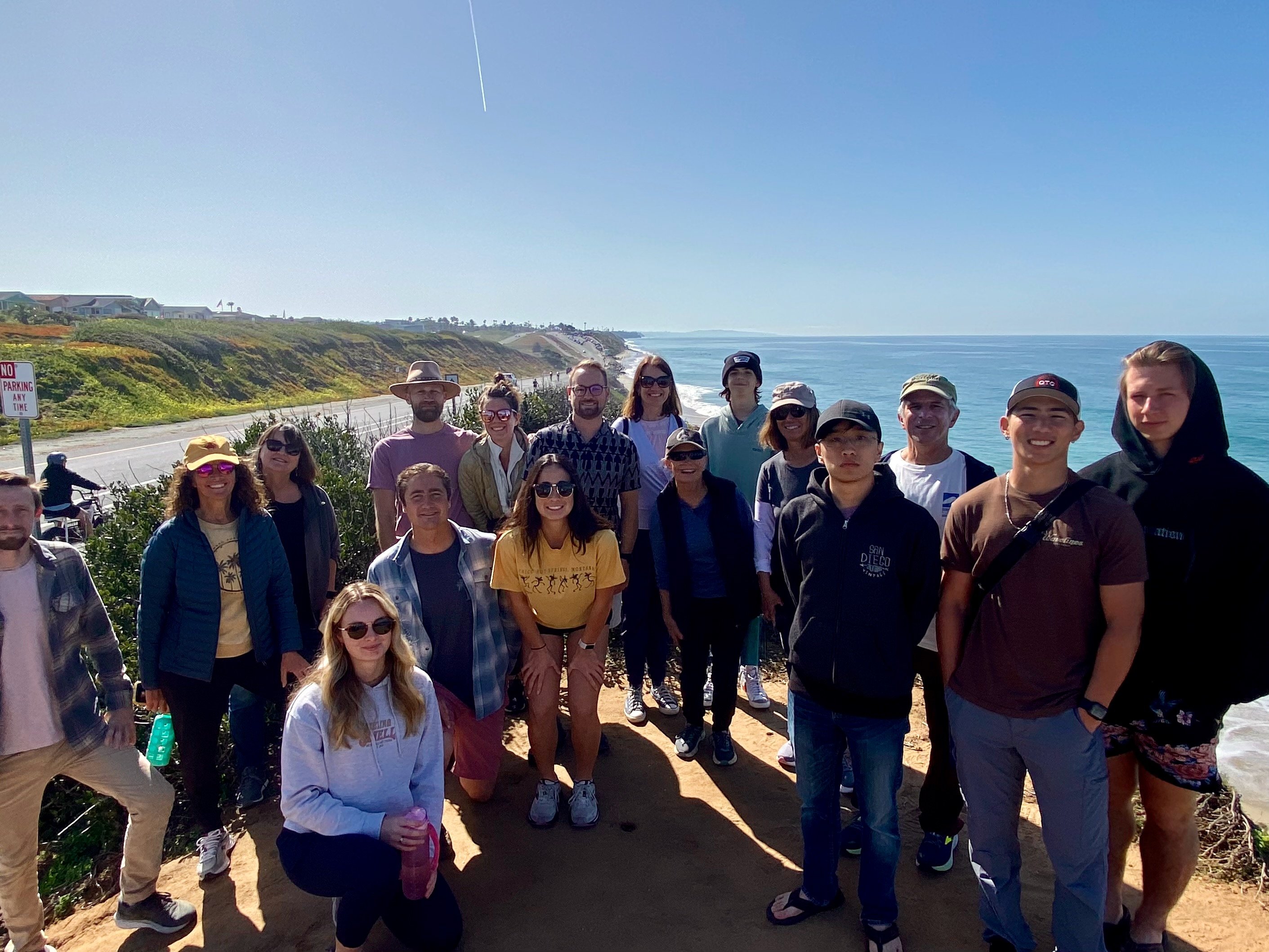
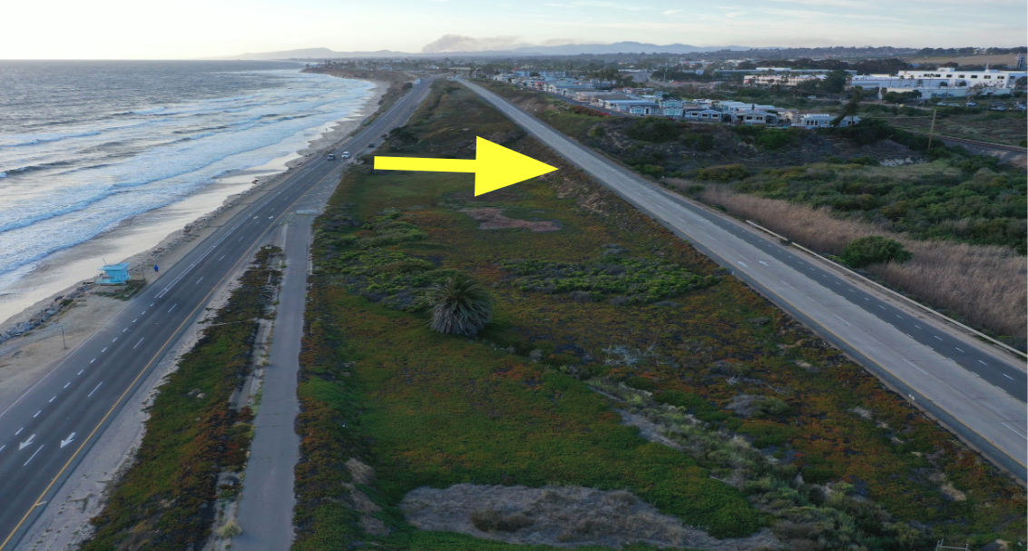
Last Sunday morning, our chapter led a “save the beach” walk along an endangered stretch of Carlsbad’s coast. We assembled at North Ponto State Beach to walk along "dip in the road," a mile-long stretch where southbound Carlsbad Blvd. descends to sea level on either side of coastal bluffs and runs right along the beach.
Unfortunately, the road runs too close to the ocean, blocking any hopes that the beach could naturally migrate landward as sea levels rise. The road already floods intermittently and has been closed to traffic in the past. Additionally, both the Army Corps and the City have placed piles of riprap (boulders) on valuable public beach space to protect the road from being undercut by waves.
To their credit, the City of Carlsbad has been proactively planning how to realign traffic away from this threatened road along the beach. During our walk, we discussed what the City has done so far, along with Surfrider’s goals to ensure this project prioritizes saving the beach in addition to saving a critical coastal road. Thanks to a 6 foot high tide during our walk, community members were able to see for themselves how the ocean is already drowning this interrupted beach while threatening the existing road.
The goal of Sunday's event was to educate the community and build support for a coastal adaptation project that, if carried out successfully, will protect a critical coastal corridor while saving a valuable public beach in an area surrounded by bluff-backed beaches that will not fare well against rising seas in the next 50-75 years.
Check out the tabs below to see some telling images and renderings of the project area. Below the tabs, you will find a detailed list of resources to learn more about this exciting coastal adaptation project.

We assembled at Tower 28 near the North Ponto lot on an absolutely beautiful Sunday morning!

The bridge at Las Encinas Creek during a 6 foot high tide, looking north. Even with minimal swell, the beach space is essentially drowned at high tide.

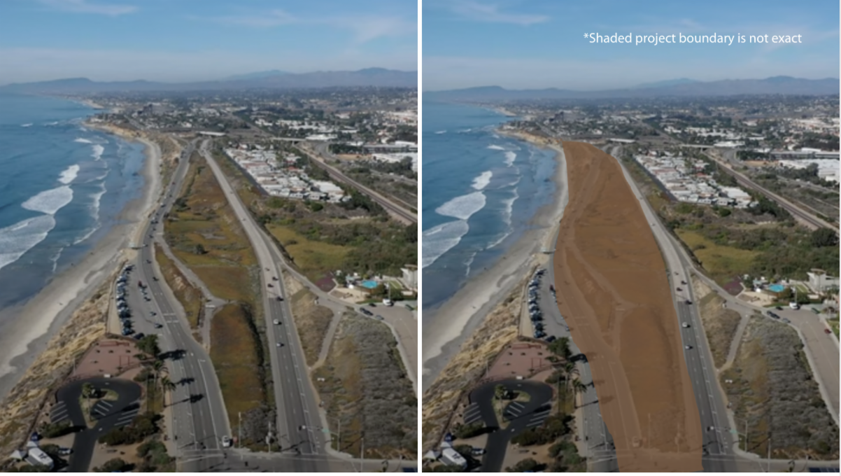
Our last stop was this vantage point, looking south at the project area. You can clearly see how narrow the beach has become, along with how much space there'd be for the beach to migrate landward if/when the road is moved.

Speaking of the existing road, the City restriped it last year. It now features only 1 traffic lane instead of 2, which allows more space for bikes and pedestrians.
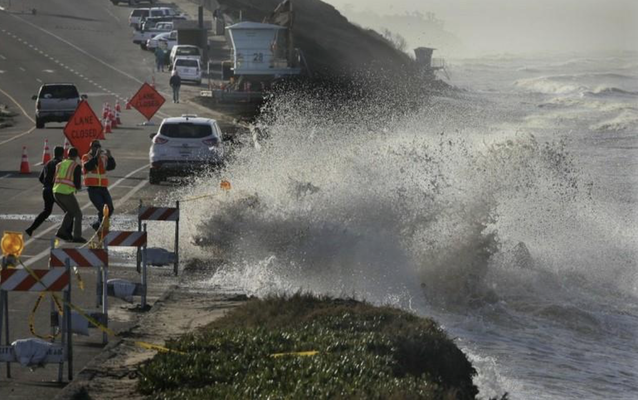
Storm surge during the 2015/16 El Niño flooded and damaged the road, prompting an emergency closure and the placement of additional boulders on the beach to protect the road.
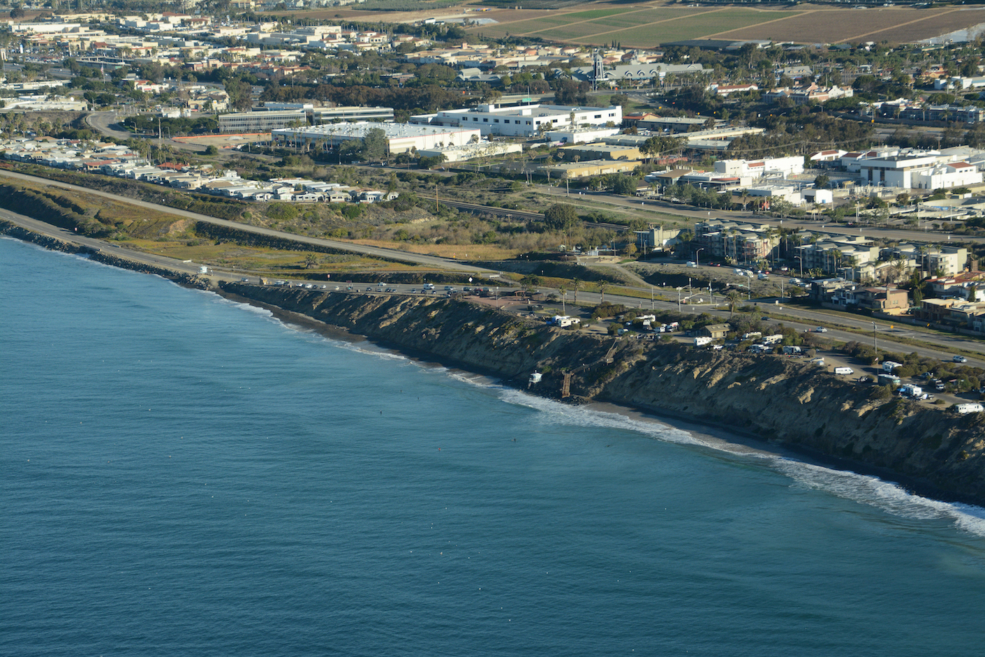
An aerial image during the 2021 King Tides shows that at a 7 foot tide, the ocean drowns the entire beach and reaches the foot of the road. Based on the latest sea level rise science, this is what a normal high tide will look like in as early as 30 years.

January 6, 2023 aka "Big Friday." This photo illustrates what happens when a sizable swell correlates with the same tide level that we witnessed during our beach walk - 6 feet. Click image to see a short video from that day.
*Click on images for a larger view
.png)
On June 20, 2023, the City Council voted to support the above-option for the new roadway. It reduces traffic to one lane in each direction, adds several roundabouts instead of traffic stops, and provides ample space for bike lanes and pedestrians.
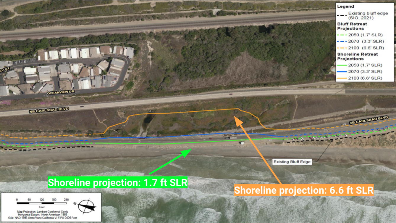
This diagram shows that if the existing S Carlsbad Blvd. is removed once traffic is rereouted, a pocket beach would form in its place with sea level rise (SLR) resilience up to 6.6 feet. If the road remains, the beach will be 100% gone after 1.7 feet of SLR, not to mention largely unusable much earlier.
A simple city-rendering of how much space we will gain by moving the southbound road inland to adjoin with the existing northbound lane.
At the end of the day, it's really that simple - move the road, save the beach.
Want to learn more about this project and the conditions that necessitate action? Peruse the resources below from both the City of Carlsbad and Surfrider. Please email beachpres@sandiego.surfrider.org if you have any questions or would like to learn more.
*Please note that this list is copied from our S Carlsbad Blvd. Coastal Adaptation Project Campaign Page. We will continue to update the Campaign page as new developments occur, so be sure to check back on that page in the future if you want to follow along on this project.
- City of Carlsbad South Carlsbad Coastline Project landing page
- Las Encinas Creek Alternatives Analysis Report
- The most detailed report available for this project. Covers sea level rise scenarios, habitat restoration options for Las Encinas Creek & Estuary, and details the Retreat Now option (which we support) vs. the Phased Adaptation (i.e. Retreat Later) option. Prepared by GHD.
- March 2022: Carlsbad Blvd Erosion Assessment
- Study includes a 3-mile area from the mouth of the Batiquitos Lagoon to Terramar beach, which includes the road realignment project area. Prepared by Scripps Institution of Oceanography.
- April 2022 Public Input Report
- Results from a citywide survey on what community members would like to see along Carlsbad Blvd. in the future. We created word clouds from the results which are featured in our April 2022 blog post, linked below.
- June 2022 Roadway Options: Manzano Dr. to Island Way
- The City Council approved Option 2 on June 20, 2023.
- Las Encinas Creek Alternatives Analysis Report
- Apr 2 2022: Blog Post - S Carlsbad Blvd Realignment Planning Begins
- Covers the project and why it's important, details community feedback from the City's public outreach efforts.
- Sep 13 2022: Letter to City Council , Support for the adaptation studies & project
- June 5 2023: Blog Post - Carlsbad Blvd Adaptation Project: RETREAT NOW
- Also covers the project thoroughly, details the road realignment options and why it's critical to demolish the existing road once realignment occurs.
- June 19 2023: Letter to City Council, Prioritize the S Carlsbad Blvd managed retreat
h It takes a community!
 Mitch served in various volunteer leadership positions with the San Diego Chapter before being hired on as Chapter Manager in 2018. In 2022, he transitioned to the chapter’s policy role. In 2025, he's broadened his scope as California's Senior Policy Coordinator.